
Outside of watching the TV Series Outlanders for its historical time-travel into the Scottish Highlands in the 1700s (or, of course, reading the novels by Diana Gabaldon’s on which the series is based), our best method for learning about the people and places of the time is through resources on the Internet. This may be a less entertaining way, but it can be rewarding. In researching the Scottish background about the Fleming Family, we have dug into several tremendous resources about Scotland’s past that includes historical accounts, maps, drawings and images, and fiction.
The Scots, with great foresight, undertook two extensive and detailed accounts of the geography, population, economy and society in the late 1790s and mid-1800s. The First (or Old) Statistical Account of Scotland (1792-99) in 21 volumes was compiled by Sir John Sinclair who engaged over 900 ministers in the parishes to report on their areas guided by his questions. The Second (or New) Statistical Account of Scotland (1834-45) was done for the Society for the Benefit of the Sons and Daughters of the Clergy in Scotland and was produced similarly.
Both may be searched and read in digital format through Statistical Accounts of Scotland Online, a superbly rich website. Use the clickable map to zoom into a county and then browse from the list for a parish, or use a keyword search. Locating the parish – for example, Logierait – leads to links to the digitized images in the sections in the Old and New Statistical Accounts. This resource was created by EDINA, a division of the University of Edinburgh’s Information Services. Searching and viewing are free, but a fee-based subscription is needed to have access to transcripts, downloads, printing, enhanced searching, and other personalized features.
Electric Scotland also has scanned pages for the Old and New Statistical Accounts obtained from Google’s book project. These are downloadable as pdfs. Also, the Internet Archive has digitized, searchable volumes and Google Books offers them as free ebooks. (Discovery is more difficult at Google Books: For the Old series, this query will pick up most – editions:hhqepV8tOD0C; for the New, use this search command, ” new statistical account of scotland“, and set Tools to “preview available.”)
EDINA also connects its entries to the Gazetteer for Scotland – an older style website, but none the less valuable.
“The Gazetteer for Scotland is a vast geographical encyclopaedia, featuring details of towns, villages, bens and glens from the Scottish Borders to the Northern Isles. The first comprehensive gazetteer produced for Scotland since 1885, it includes tourist attractions, industries and historical sites, together with histories of family names and clans, biographies of famous Scots and descriptions of historical events associated with Scotland. The network of connections between all of these entries makes this gazetteer unique. We have included the text of Groome’s 19th Century Ordnance Gazetteer of Scotland to provide a historical perspective on many of the places we describe.” [Copyright notice]
The “19th Century Ordnance Gazetteer” mentioned is a tremendous discovery, and part of the extensive digital collection of the National Library of Scotland. The links from the Gazetteer will take you directly to a historical map.
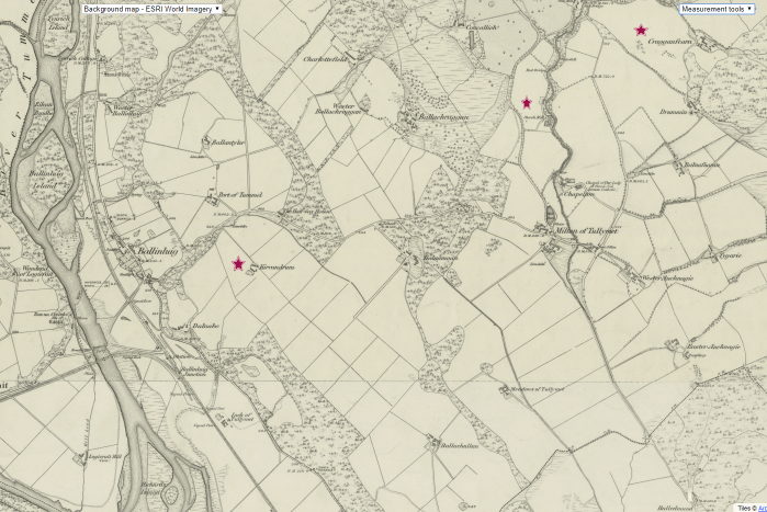
We obtained this view of a section of Logierait parish showing Kirrandrum, where James Stewart was a tenant farmer for the Duke of Atholl (star on the left), the Anderson starch mill that Alexander Fleming managed near Tulliemet Burn, and Cragganfearn to the west where another branch of Flemings lived.
For maps galore, the starting point would be National Library of Scotland: Maps Images – organized by category or project, and searchable by place name. We can search for Logierait, select a map type – Scotland Ordnance Survey maps, and specific map series – OS Six inch, 1840s-1960s. The site is a bit difficult to navigate but worth the time.
If your interest is present day, the Ordnance Survey site (https://www.ordnancesurvey.co.uk/shop/) has print and digital maps.
Canmore has more maps and more history. This is the impressive work of Historic Environment Scotland – “the lead public body established to investigate, care for and promote Scotland’s historic environment” – with collections of photographs, drawings, maps, and aerial views. The Canmore database delivers access to information about more than 300,000 historic places in Scotland. There are several search options: site records, catalogs, thesaurus, and archaeology insites. Unfortunately, it has no photographs or maps of Kirrandrum, home to Alexander Fleming and his wife Jean Stewart, but there are several of the starch mill near Tulliemet.
⇒ See Fragmentary remains of mill: SE wall standing on bank of Tullymet Burn.
Roy Fleming found another way to time-travel to the Highlands – read Sir Walter Scott. As Roy wrote to his cousin C.A. Fleming in Owen Sound (14 October 1903),
“I find that on the good authority Sir Walter Scott that Perthshire is the fairest part of Scotland. No other single shire has its variety of mountain scenery, of hills, valleys, crags and lochs, as our own Scottish shire – and equal in history and traditions to any part of the Highlands.”
Waverley and The Fair Maid of Perth are the most frequently mentioned novels for scenes set in Perthshire, easily downloaded from the Internet Archive or Amazon at little to no cost.
