Walking Kirrandrum

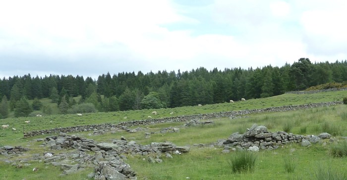
In June 2018 I had the great pleasure of visiting the Highlands of Scotland to walk the land of the Fleming home of Kirrandrum, the farm outside Ballinluig in Logeirait Parish.  I was guided by Eddie Thomson of Heartland Tours. We found the remains of Alexander’s house, which he built himself, and some of the other buildings, as well as the dry-stone wall Alexander built and which still stands intact. Most of all,  we saw surrounding hills and the Tay valley almost as they were when Roy Fleming and family members visited in 1903, and even as the Fleming family saw them when they left for Canada in May 1843.

A complete account of the visit with photos and video and reference to Roy Fleming’s description of his visit is provided in Walking Kirrandrum June 2018

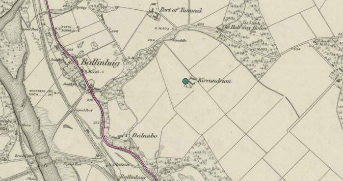
The map below from Canmore shows the location of Kirrandrum relative to Ballinlluig and to the adjacent Dalnabo.

Ballinluig area showing Kirrandrum and Dalnabo. Source: Canmore - Ordnance Survey 1843-1882.
Ballinluig area showing Kirrandrum and Dalnabo. Source: Canmore – Ordnance Survey 1843-1882.

Visit to Cragganfearn

P1040348-cragg-sheep-2
Cragganfearn looking east – rock foundations, wall, and sheep in the background (Photo: G Harris)

Where there had once been a village of four families at “Upper Cragganfearn”, only the crumbling walls of a steading and the foundations to a few cottages and farm buildings remain.

Sheep graze in the fields of this quiet place. It was windy on the sunny June afternoon when Eddie Thomson of Heartland Tours led me to the site. Along the small stream, he pointed out the remnant of what might have been a sawmill. Past the gate, we could see a stone building that still stood high on the hill. We made our way uphill on a path and across the fields, nodding to the nearby sheep, to come to marvellous panoramic views of the hills. Continue reading

More maps and drawings at Scotlands People

National Records of Scotland has released to Scotlands People “more than 2,400 historic maps, plans and drawings”  that show country estates and plans of towns and cities.

See News Article: Maps and Plans Release (June 13, 2018).

Spanning four centuries, the collections cover both manuscript and printed topographical maps and plans. They are particularly strong in estate and railway plans; architectural drawings; and engineering drawings, particularly of ships, railway engines and rolling stock. More maps and plans will be added to the ScotlandsPeople website.

Requires free registration at Scotlands People to access and search

A search on Atholl delivers “Plan of the estates of Fincastle, Borenich, Lick and Duntaulich, Blair Atholl” (RPH6594). Dated 1832, this map shows the lands along the Tummel River.

Speaking of Scottish resources, Ancestral Findings offers this list of  Online Resources for Researching Your Scottish Ancestors.  Scotlands People and five others (including Family Search) are described here, and there are links to other postings related to Scotland.